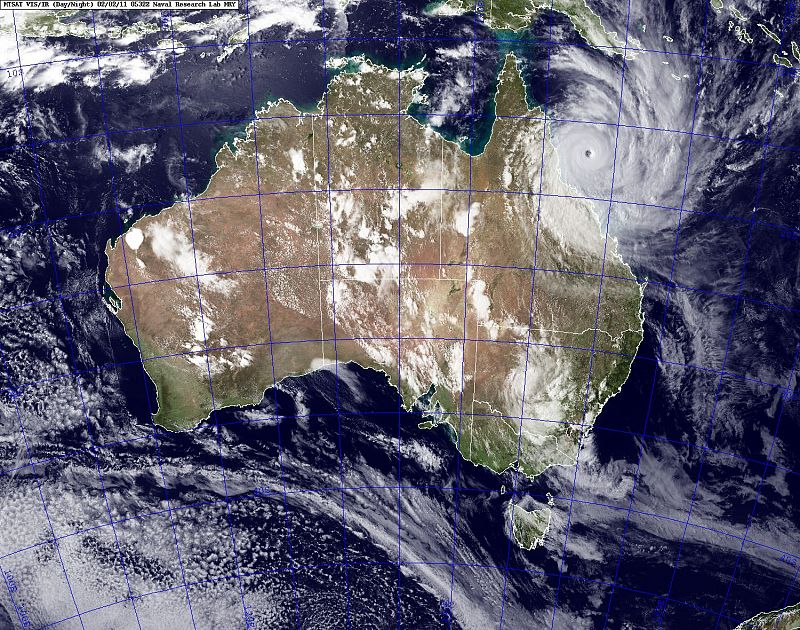
El ciclón Yasi en Australia
El ciclón Yasi en Australia
-
A satellite image shows Cyclone Yasi approaching the coast of Australia
02.02.2011A satellite image obtained from the U.S. Naval Research Laboratory shows Cyclone Yasi approaching the coast of Australia on February 2, 2011. REUTERS/U.S. Naval Research Laboratory/Marine Meteorological Division/Handout (AUSTRALIA - Tags: DISASTER ENVIRONMENT IMAGES OF THE DAY) FOR EDITORIAL USE ONLY. NOT FOR SALE FOR MARKETING OR ADVERTISING CAMPAIGNS. THIS IMAGE HAS BEEN SUPPLIED BY A THIRD PARTY. IT IS DISTRIBUTED, EXACTLY AS RECEIVED BY REUTERS, AS A SERVICE TO CLIENTSREUTERS/U.S. Naval Research Laboratory/Marine Meteorological Division/Handout -
Una cafetería de la ciudad de Cairns (Australia), protegida para resistir los vientos de hasta 300 kilómetros por hora del ciclón Yasi
02.02.2011A cyclone-prepared cafe sports taped glass and sandbagged doors in the northern Australian city of Cairns February 2, 2011. Category five Cyclone Yasi, expected to be the most powerful storm to cross Australia's heavily populated east coast in generations, is expected to make landfall late on Wednesday night. Thousands of people fled their homes and crammed into shelters in northeastern Australia on Wednesday as the cyclone with a 650 km (400 mile) wide front barreled toward a string of popular tourist cities lining the coast. REUTERS/Tim Wimborne (AUSTRALIA - Tags: DISASTER ENVIRONMENT)REUTERS/Tim Wimborne -
Man wheels bedding into an emergency cyclone shelter at a shopping mall in the northern Australian city of Cairns
02.02.2011A man wheels bedding into an emergency cyclone shelter at a shopping mall in the northern Australian city of Cairns February 2, 2011. Catagory five Cyclone Yasi, expected to be the most powerful storm to cross Australia's heavily populated east coast in generations, is expected to make landfall late on Wednesday night. Thousands of residents fled their homes and crammed into shelters in northeastern Australia as the cyclone with a 650 km (400 mile) wide front barreled toward the coastline on Wednesday. REUTERS/Tim Wimborne (AUSTRALIA - Tags: DISASTER ENVIRONMENT IMAGES OF THE DAY)REUTERS/Tim Wimborne
Últimas fotogalerías Noticias
Ver más


